The Building of the First Aswan Dam and the Inundation of Lower Nubia:
The Nile River is the main artery for Egypt and Nubia: the present course of the river, traceable to at least 25,000 years ago, is a determining factor of the topography of the region. In a relatively rainless reigon, it is only because of the river's annual flood that these areas became habitable and airable.
The yearly flood of the Nile is caused by late summer rains in the plateau region of Ethiopia, which in turn swell the tributaries of the Nile. At the peak of the flood, the volume of the river's flow increases by as much as sixteenfold. Variable amounts of rainfall to Ethiopia cause stunning differences in the amount of flooding seen farther down the course of the Nile. In a "lean year," such as 1913-1914, 12 billion cubic meters of flood water swelled the river. A "fat year," such as 1878-79, saw the level of the river increase by 155 billion cubic metets of water.
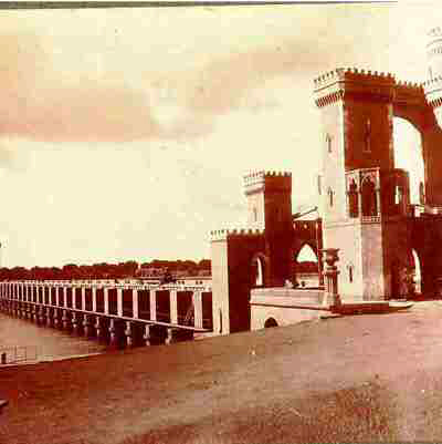
At the turn of the century, agricultural production was being outstripped by the growth of the population in Egypt and the Sudan: the Nile had to be controlled if there was to be agricultural stability along its banks. Harnessing the power of the Nile would also yield the hydroelectric power necessary for industry. To the increasingly industrial societies of the region, the choice was clear. In 1899, construction of the first Aswan Dam was begun. Completed in 1902, its height was raised in subsequent building campaigns of 1907-12 and 1929-34. Even with these renovations, the first, or "Low," dam proved to have an inadaquate reservior area. In the event of extreme flooding, it would be necessary to open the sluices of the dam to relieve the water pressure against it, flooding the areas thought to be protected. A second dam was necessary at Aswan, and in the early 1950s, designs began to be drawn for what was to become the High Dam as Aswan. With the signing of the Nile Water Agreement by Egypt and the Sudan in November of 1959, work began on the second Aswan dam.